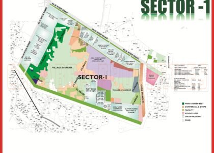
This Sigma 1 Greater Noida Map guide explains the plots, roads and facilities in detail. Sigma 1 is also marked on the Authority’s plan as Sector 42, which is why buyers search for both names. It is a large, planned plotted sector with just two plot sizes, wide 80 m and 60 m boundary roads, a big integrated school complex and two master-plan commercial belts.
This guide reads the official Sigma 1 layout plan and its area statement for you. The full interactive version is on our Sigma 1 map page.
Sigma 1 Sector Map
The layout plan below shows the two plotted blocks (A and B), the integrated school complex, parks, facility sites and the commercial belts on the east. Click the image to open it in full size, or download the PDF to read plot numbers.

Where Sigma 1 Sits: Neighbours and Boundary Roads
- North: Sector 36 (marked RHO-1), across a 60 m wide road.
- West: Sector 4, an UPSIDC industrial sector, with a 60 m wide road and green belt in between.
- East: an 80 m wide road with a master-plan commercial belt; beyond it lies Sigma 2.
- South: an 80 m wide road with a green belt.
Read next: Sigma 2 map guide and Sigma 3 and Sigma 4 map guide.
Sigma 1 Map Data: Plots and Area Statement
Sigma 1 has only two plot sizes, which makes it easy to understand:
| Plot area | Dimensions | Approx. size | Plots |
|---|---|---|---|
| 500 sq m | 31.25 m × 16 m | 5,382 sq ft | 297 |
| 300 sq m | 24 m × 12.5 m | 3,229 sq ft | 748 |
That is 1,045 plots in total. The 500 sq m plots (salmon on the plan) sit in Block A in the north, while the 300 sq m plots (blue) fill Block B in the south. The area statement shows how the net sector area of about 85.9 hectares is used:
| Land use | Area | Share |
|---|---|---|
| Residential development | 41.27 ha | 48.0% |
| Roads | 23.05 ha | 26.8% |
| Green areas (including parks) | 15.03 ha | 17.5% |
| Facilities | 6.60 ha | 7.7% |
Outside the net area, the plan also sets aside about 7 ha for master-plan commercial belts, 2.9 ha for village abadi and 4.6 ha for the master-plan green belt. The planned population is about 11,575 people, with about 55.7% of the area saleable.
Sigma 1 Layout: Blocks, School Complex and Facilities
- Block A (north): 500 sq m plots on 12 m and 9 m roads, with a central park and a facility strip.
- Block B (south): 300 sq m plots in long rows between 12 m and 18 m roads, with several parks and a community hall site.
- Integrated school complex: a large school site in the north-west corner, a major plus for families.
- Nursery school and facility sites in the middle of Block B, and a community centre beside a central park.
- Informal sector housing area of about 2.3 ha, kept separate from the main plots.
- Commercial belts: two master-plan commercial belts on the east side, along the 18 m and 80 m roads.
What to Check on the Sigma 1 Map Before You Buy
- Confirm whether your plot is in Block A (500 sq m) or Block B (300 sq m).
- Check what faces the plot: park, 9 m, 12 m or 18 m road, or the green belt.
- Note the distance to the commercial belt on the east and the school complex in the north-west.
- Ask for the lease deed, dues certificate and permitted floors.
- Compare rates with Omicron 1 and Sigma 2 before negotiating.
Sigma 1 on Google Maps
The pin below marks Sigma 1 on Google Maps so you can check distances to Pari Chowk, the Aqua Line stations and the nearest markets.
Explore Related Greater Noida Maps
- Sigma 1 map
- Sigma 2 map
- Sigma 3 map
- Sigma 4 map
- Sector 36 map
- Omicron 1 Greater Noida map guide
- Greater Noida Sector Map 2026 guide
Frequently Asked Questions
Is Sigma 1 the same as Sector 42?
Yes. The Authority layout plan is titled Sigma-I, Sector-42, so both names refer to the same sector.
How many plots are there in Sigma 1?
The plan lists 1,045 plots: 748 of 300 sq m and 297 of 500 sq m.
Which sectors border Sigma 1?
Sector 36 (RHO-1) lies to the north and Sector 4 (UPSIDC industrial) to the west, with Sigma 2 across the 80 m road on the east.
Does Sigma 1 have a school site?
Yes. A large integrated school complex is marked in the north-west corner, with a nursery school site in Block B.
Where can I download the Sigma 1 map?
Use the PDF button above or visit our Sigma 1 map page.
Use this Sigma 1 Greater Noida Map together with the official layout plan, and verify plot numbers and road widths with the Greater Noida Authority before you decide. The Sigma 1 Greater Noida Map above is a reference guide for planning your visit.
Anyone comparing plots should read the Sigma 1 Greater Noida Map alongside the nearby sector plans. Each Sigma 1 Greater Noida Map page on this site lists plot sizes, road widths and facility sites, so you can shortlist the right plot with confidence.
Need the Latest Sigma 1 Map or Plot Availability?
Chhabra Properties helps buyers, sellers and investors with plots, houses, floors and flats across Greater Noida from its office in the Alpha 1 Commercial Belt. Ask us for the latest Sigma 1 layout, plot availability and current rates.
Office: 204, S L Tower, Alpha-I Commercial Belt, Greater Noida, Uttar Pradesh 201310