This Mu 1 and Mu 2 Greater Noida map guide explains the plots, roads and commercial belt of both sectors. Mu 1 and Mu 2 are the two plotted and village-linked sectors next to Sector Mu. Mu 1 has a classic plotted layout with small and mid-size plots in four blocks, while Mu 2 is a proposed plan built around the village of Ghori Bachera and a large group housing plot.
This guide reads both official layout plans. The map pages are on our Mu 1 map page and Mu 2 map page; for the group housing sector next door, see the Mu map guide.
Mu 1 and Mu 2 Greater Noida Map: Sector Overview
Both layout plans are shown below. Click either image to open the full-size map, or download the PDFs to read plot numbers.
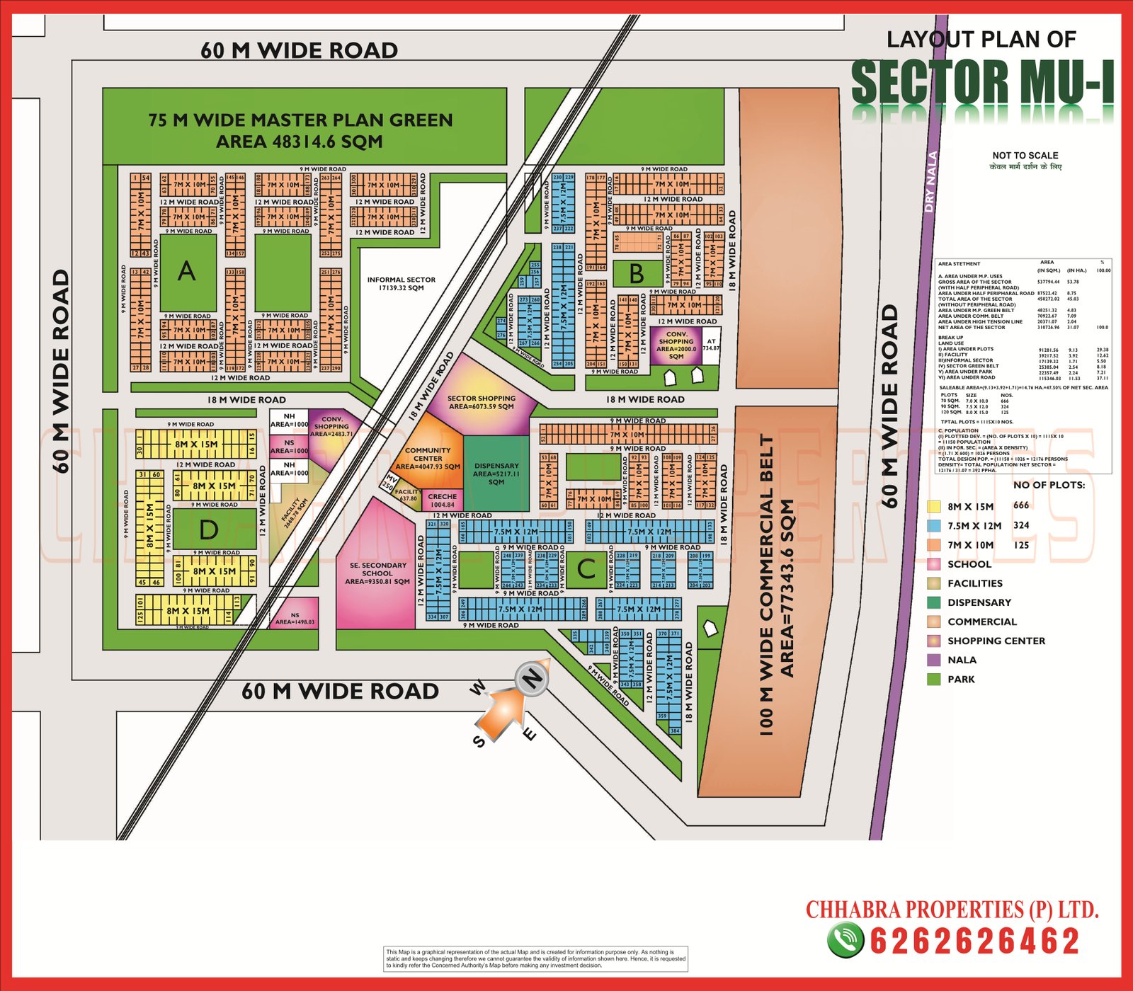
Mu 1 Map Data: 1,115 Plots in Three Sizes
| Plot area | Dimensions | Approx. size | Plots |
|---|---|---|---|
| 120 sq m | 8 m × 15 m | 1,292 sq ft | 666 |
| 90 sq m | 7.5 m × 12 m | 969 sq ft | 324 |
| 70 sq m | 7 m × 10 m | 753 sq ft | 125 |
Mu 1 therefore offers 1,115 plots, all small to mid-size, which suits first-time buyers and builder-floor investors. Key features of the plan:
- Four blocks (A, B, C and D) laid out on 9 m, 12 m and 18 m roads.
- Railway line: a line cuts diagonally through the middle of the sector, so check how far a plot is from it.
- 75 m wide master-plan green belt of about 4.8 ha in the north.
- 100 m wide commercial belt of about 7.7 ha on the east side, beside a 60 m road and a dry nala.
- Facilities: a senior secondary school, community centre, dispensary, sector shopping, convenience shopping, creche and nursing-home sites near the centre.
- Informal sector: a pocket of about 1.7 ha.
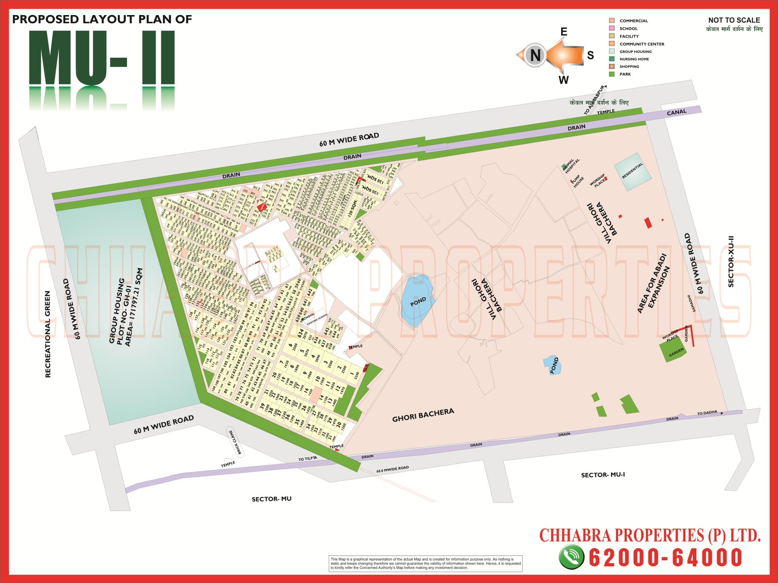
Mu 2: A Village-Centred Proposed Layout
The Mu 2 plan is marked “proposed” and looks very different from Mu 1. It is built around the existing village of Ghori Bachera:
- Group housing: plot GH-01 of about 171,797 sq m (17.2 ha) on the western side, framed by a green belt.
- Village abadi and expansion: a large area is marked for the village and for abadi expansion on the east, with ponds and drains running through it.
- Resettlement plots: a dense pocket of small plots in the north-west, with several temples and public sites marked.
- Roads: 60 m wide roads on the west, north and east, and a 60 m road with a drain on the south.
- Neighbours: Sector Mu to the south-west, Mu 1 to the south and Sector Xu 2 to the east.
Because Mu 2 is a proposed plan with village land, drains and ponds, always check the latest approved version with the Authority before buying anything there.
What to Check Before Buying: Mu 1 and Mu 2 Greater Noida Map Notes
- For Mu 1, confirm the block (A to D), plot size and distance to the railway line.
- Check what faces the plot: park, 9 m or 12 m road, 18 m road or the commercial belt.
- For Mu 2, verify that the plan is final and the land is not part of the village abadi.
- Ask for the lease deed, dues certificate and permitted use.
- Compare with Sigma 3 and Sigma 4 if you want a newer plotted layout.
Mu 1 and Mu 2 on Google Maps
The pin below marks Mu 1 on Google Maps so you can check distances to the main roads and nearby sectors.
Explore Related Greater Noida Maps
Frequently Asked Questions
How many plots are there in Mu 1 Greater Noida?
The Mu 1 plan lists 1,115 plots: 666 of 8 m x 15 m, 324 of 7.5 m x 12 m and 125 of 7 m x 10 m.
Does a railway line pass through Mu 1?
Yes. The layout plan shows a railway line crossing the sector diagonally, so check each plot’s distance from it.
What is Mu 2 Greater Noida?
Mu 2 is a proposed layout around village Ghori Bachera, with a group housing plot of about 17.2 hectares, abadi expansion land and resettlement plots.
Which sectors border Mu 2?
Sector Mu and Mu 1 lie to the south and Sector Xu 2 to the east.
Need the Latest Mu 1 and Mu 2 Greater Noida Map?
Chhabra Properties helps buyers, sellers and investors with plots, flats and group housing across Greater Noida from its office in the Alpha 1 Commercial Belt. Ask us for the latest layout, availability and current rates.
Office: 204, S L Tower, Alpha-I Commercial Belt, Greater Noida, Uttar Pradesh 201310