Zeta 1 is very different from the plotted sectors around Pari Chowk. Its official layout plan is dominated by group housing plots, a large village abadi and wide green belts, with only a small pocket of residential plots on the eastern side. That is why the “Zeta 1 Greater Noida map” is searched by flat buyers, builders and investors, not just plot hunters.
This guide reads the Zeta 1 plan for you: where the group housing sites are, what the roads and green belts do, and what to check before buying. The full interactive version is on our Zeta 1 map page.
Zeta 1 Sector Map
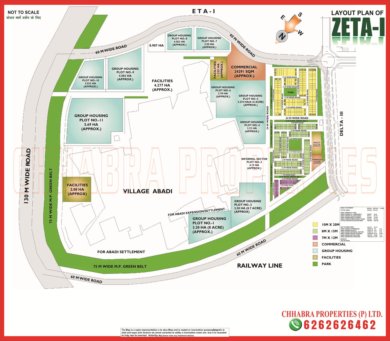
The layout plan below shows the group housing plots (numbered 1 to 11), the commercial site, facility pockets, the informal sector plot, the village abadi and the residential plot pocket on the east. Click the image to open it in full size, or download the PDF.
Where Zeta 1 Sits and What Surrounds It
The plan labels the sectors and roads around Zeta 1, so its position is easy to read:
- North: Eta 1, separated by a 60 m wide road that curves around the top of the sector.
- East: Delta 3, with the main residential pocket of Zeta 1 facing that side.
- West: a 130 m wide road with a 75 m wide master-plan green belt beside it.
- South: another 60 m wide road with a 75 m green belt and the railway line beyond it.
For the neighbouring layouts, see our Zeta 2 and Eta 2 map guide and the Eta 1 map guide.
Zeta 1 Layout: Group Housing, Abadi and Facilities
- Group housing: eleven numbered plots wrap around the north and east of the sector. Plot 11 (about 5.7 ha) is the largest, followed by Plots 8 and 9 (about 4.6 ha each); Plots 1 and 2 on the south side are roughly 3.2 and 3.5 ha.
- Village abadi: a very large abadi sits in the middle of the plan, with an expansion area marked for settlement. Always check how close a plot or project is to it.
- Commercial: a commercial site of about 24,000 sq m near the north-east corner, close to the main junction.
- Facilities: one pocket of roughly 4.3 ha and another of about 2 ha, plus a small facility site on the residential side.
- Informal sector: a plot of about 4 ha reserved for informal-sector housing.
- Residential plots: a compact pocket on the eastern edge with 10 m × 20 m (200 sq m), 8 m × 15 m (120 sq m) and 7 m × 12 m plots around small parks.
Sizes marked “approx.” on the plan can change in final allotments, so confirm each number against the latest approved layout.
Who Should Look at Zeta 1?
- Flat buyers looking at group-housing projects in a large, open sector.
- Investors who prefer to buy early in a sector that is still developing.
- Small-plot buyers who want a 120 or 200 sq m plot in the compact residential pocket.
If you want a fully built, plotted neighbourhood close to the metro, Alpha 1 or Beta 1 are better matches.
Zeta 1 Connectivity: Roads, Rail and Metro
| Mode | Details |
|---|---|
| Roads | 130 m wide road on the west; 60 m wide roads on the north and south; 24 m internal roads |
| Rail | Railway line runs along the southern edge of the sector |
| Metro | Aqua Line Depot and GNIDA Office stations are the closest, a few kilometres away |
| Airport | Noida International Airport, Jewar, via the Yamuna Expressway |
Property portals place Zeta roughly 3 to 4 km from the Depot station. Check the exact distance for your plot on Google Maps below.
What to Check Before Buying in Zeta 1
- Confirm the group housing plot number and the builder’s allotment papers with the Authority.
- Check RERA registration and the sanctioned map for any project.
- Note the distance to the village abadi, the railway line and the green belts.
- For plots, match the plot number and size (7 m × 12 m, 8 m × 15 m or 10 m × 20 m) with the layout.
- Ask for the latest possession and dues status.
Zeta 1 on Google Maps
The pin below marks Zeta 1 on Google Maps so you can check the distance to the Depot and GNIDA Office metro stations, schools and markets.
Explore Related Greater Noida Maps
- Zeta 1 map
- Zeta 2 map
- Eta 1 map
- Delta 3 map
- Delta 1 Greater Noida map guide
- Greater Noida Sector Map 2026 guide
Frequently Asked Questions
Where can I download the Zeta 1 Greater Noida map?
You can view and download the Zeta 1 map as JPG or PDF on our Zeta 1 map page or use the PDF button in this guide.
Is Zeta 1 mainly group housing?
Yes. The layout plan marks eleven group housing plots, which take up most of the sector, with a smaller residential plot pocket on the east.
Which sectors border Zeta 1?
Eta 1 lies to the north and Delta 3 to the east. A 130 m wide road runs along the west and the railway line along the south.
What plot sizes are available in Zeta 1?
The residential pocket shows 10 m x 20 m (200 sq m), 8 m x 15 m (120 sq m) and 7 m x 12 m plots.
What is the PIN code of Zeta 1 Greater Noida?
Zeta 1 falls under PIN code 201310.
Need the Latest Zeta 1 Map or Project Details?
Chhabra Properties helps buyers, sellers and investors with plots, flats and group housing across Greater Noida from its office in the Alpha 1 Commercial Belt. Ask us for the latest layout, availability and current rates in Zeta 1.
Office: 204, S L Tower, Alpha-I Commercial Belt, Greater Noida, Uttar Pradesh 201310